Fieldwork in the Atacama Desert, Chile

Friday 18 July 2014

The Geology of the Peak Grit

With the majority of my time working on the PhD at the moment spent just reading papers while sitting around waiting for a final massive data set to work on and the mass spectrometer to be fixed so I can finally finish my data collection, I'm at a bit of a loss as to what to do with myself. This gives me a perfect excuse to put together this blog post I've been meaning to write for a while now, bringing together two of my favourite things: geology and climbing.

Now obviously rock climbing couldn't exist without rocks to climb on, but how many climbers just don’t think about the geological events that led to forming the strata they are clinging on to?

The UK is very varied in its geology for quite a small area and this gives a wide range of interesting rock types to climb on. There is the world famous grit of the Peak District, the slates and volcanic rocks of Snowdonia and the Lake District, the Granite of Cornwall and Dartmoor, and the limestones of Avon, Cheddar and Dorset, all with their own characteristics, challenges and history.

This is going to be a short series of posts covering these rock types in turn, starting where I've done most of my climbing so far, the grit of the Peak District.

The Peak District is split roughly into 2 regions defined by rock type; the gritstone of the Dark Peaks in the North, far West and East and the limestone of the White Peaks in the Central and Southern areas, with these 2 areas separated by softer low-lying shales.


This can be well seen in Figure 1, a simplified Geological map and Figure 2, a cross section , as the structure of the Peak District is a broad anticlinal dome. The sediments that were originally deposited flat have been uplifted and erosion of the overlying sediments has exposed a concentric pattern with the oldest rocks (the limestones) in the core of the dome. This occurred as a result of the Variscan Orogeny around 290 million years ago as (what are now) North America and Europe collided to form the supercontinent Pangea.

Figure 1: Simplified geological map of the Peak District (source)

Figure 2: Simplified cross section of the Peak District (source)
The Geological history of this area therefore starts with the deposition of the limestones of the White Peak. During the early Carboniferous period, between 350 and 325 million years ago, what is now the British Isles were located near the equator and much of the country was covered in a shallow tropical sea, a back-arc extensional basin to the north of the Variscan orogenic belt. As the supercontinent of Pangea formed, the Iapetus Ocean closed during the Late Silurian and Devonian and mountains were growing through central and northern Europe as continental plates moved together. In this rapidly subsiding basin, warm shallow marine environments allowed for a great abundance of life and a great thickness of fine grained limestone was deposited in which fossils of corals, crinoids, brachiopods and trilobites can be found.


Stromataporid or bryozoan (?) found while scrambling the Pinnacle at Parkhouse Hill (SK077670) in the White Peak

As well as the steep sides of cliffs of the valleys, where water and ice have eroded down through the soluble rock, the limestone has also been extensively quarried as a building material and the abandoned quarries provide popular climbing walls. Many of these quarries have been extensively bolted for sport climbing and although it also means it’s often weathered smooth and crumbly, the solubility of limestone allows it to erode into some interesting and challenging holds. More on limestone climbing in a later post though, it’s the overlying grit the Peaks is famous for.

After subduction and mountain building had ended towards the end of the Carboniferous, subsidence of the basin slowed and now sediment supply outpaced subsidence. Uplift to the North of the Peak District, in the area which is now Scotland and Scandinavia, created high landmasses which shed vast quantities of sediments as they were rapidly eroded. The shallow sea was gradually filled; choking the sensitive reef ecosystems and overlying the limestone with a coarsening upwards sequence of shales, silts and sands. This occurred as deltas of huge river systems, comparable in size and importance to the modern Mississippi or Amazon , grew southwards eventually depositing the coarse sands, grits and pebbles that make up the Millstone Grit, that the Peak district is famous for, around 315 million years ago. 

The location of the Variscan (also known as the Hercynian) mountain belt (source)

As the tops of the deltas stabilised, as the UK was around 30 degrees south at the time, tropical swamps developed. These were rich in plant life and over time layers of dead plant material built up in stagnant swamps. This formed the coal measures which overlay the gritstones at the far west and east of the Peak District as well as over much of the north of England. It was these coal measures that fuelled the industrial revolution, powering the factories and mills of northern England.

Carboniferous coal swamp  (source)

Inversion and uplift due to compressive effects at the culmination of the Varsican orogeny at the end of the Carboniferous caused the doming of the strata as we it see today (Figure 2). This folded and fractured the rock and erosion during the ice ages of the Quaternary have shaped the peak district as we see it now, with rivers and glaciers removing the overlying sediments and carving out valleys. This has exposed the long Edges of grit, such as Stanage and Froggart, resistant to erosion as the softer silts and coal measures have been eroded away.

Stanage edge (from Stanage Plantation)

I learnt to climb outside in the Peak District on the grit slabs at places like Stanage, Froggart and Birchen. Here, trad climbing and bouldering are the only ways to go, carrying and placing your own protection from a cumbersome and clanky rack as you struggle up the face. Here, routes are single pitch and short, sport climbing is for wimps and seemingly blank slabs are climbed with minimal protection. It’s the coarse size and angular shapes of the sharp sand particles that give the grit both its ridiculous levels of friction, allowing the confident climber to smear up a blank face, and its less favourable ability to shred your fingers on unweathered edges. These features come from the highly quartz-rich source rocks that the sediment was eroded from, they provided strong, tough grains resistant to erosion, and the proximal nature of the deposits (the sediment wasn’t transported too far from its source region) means the rivers didn’t have time to weather the particles too small and smooth.

My trad rack, pretty much all of this needs to be carried on longer routes
Taking advantage of a large horizontal break for a rest on a run out slab


Cross bedding, ripples, erosional surfaces and pebble beds from the transport of the sediment by river channels and marine currents provide plenty of holds, while horizontal breaks in the rock, where softer, finer grain sediments were deposited due to a decrease in the power of the current as channels switched around may provide a welcome ledge for a rest, or if deep and narrow enough, a desperately needed cam placement.


Deep vertical fissures in the rock are a regular feature of grit, these may have originated during the uplift and folding of the strata into the wide dome structure (Figure 2) and/or may be from the rock ‘bouncing back’ after being uncompressed due to the erosion of overlying strata or due to the melting of the ice that covered much of the UK during the glaciations of the Pleistocene (isostatic rebound). These cracks provide handy places to stick a hex or cam for protection and due to the highly compacted and cemented nature of the grit, thanks to the level of burial and compression the rock has undergone over the last 300 million years, these placements are usually pretty bomber so you can take a good fall without worrying about the rock breaking and your gear popping out (which is more of a worry with other rock types like slate). The deep cracks and fissures in some areas have also led to the Peak District being popular for crack climbing; jamming body parts – usually a few fingers, a flattened hand or a fist, but can be a knee, a shoulder or your face depending on the size and awkwardness of the crack.


Jimbo working his way up a fracture, a nice erosional river channel deposit can be seen forming the overhang above his head


I hope this has gone some way to explaining the geology of the Peak District’s grit climbing scene and hopefully they’ll be a post on limestone and sport climbing on the South Coast in the next few weeks (after I’ve been down there again for a reminder).

References:

  • Allen, J. R. 1960, The Mam Tor Sandstones: A "Turbidite" Facies of the Namurian Deltas of Derbyshire, England. Journal of Sedimentary Petrology, Vol. 30 (1960)No. 2. (June), Pages 193-208
  • Catt, J.A., 2007; The Pleistocene glaciations of eastern Yorkshire: A review; Pro. York. Geo. Soc., v. 56, p 177-207
  • Ewbank, G., Manning, D. A. C., & Abbott, G. D. (1995). The relationship between bitumens and mineralization in the South Pennine Orefield, central England. Journal of the Geological Society152(5), 751-765.

  • Gilligan, A., 1920 (for 1919), The petrography of the Millstone Grit of Yorkshire: Geol. Soc. London Quart. Jour., v. 75, p. 251-294.
  • Leeder, M. R. "Recent developments in Carboniferous geology: a critical review with implications for the British Isles and NW Europe." Proceedings of the Geologists' Association 99.2 (1988): 73-100.
  • Sorby, H. C., 1859, On the structure and origin of the Millstone Grit in South Yorkshire: Yorkshire Geol. and Polytech. Soc. Proc., v. 3, p. 669-675.


Tuesday 13 May 2014

My first conference, EGU 2014


Last week (and after less than 20 hours after returning from the Slapton field course) I flew over to the European Geosciences Union (EGU) conference in Vienna, Austria. This is an annual event where both academic and industrial research scientists present their latest findings across the whole spectrum of the geosciences – from deep earth geophysics to astrobiology and everything in between.


I was attending to present my poster ‘The Mediterranean coral Cladocora caespitosa as a high resolution Pleistocene palaeoclimate archive’ basically summing up my lab results from the last few years as part of a session on isotopes and palaeoclimate. This was my first conference, as it’s taken nearly three years of research to get enough data to be worth talking about. It’s kind of depressing to see how easily three whole years of work can fit onto a single sheet of paper…

As much of my poster as I can post on here, it's all unpublished cutting edge stuff everybody's going to well want to plagiarise...maybe
Arriving to my hotel around midnight, still broken from the aforementioned week’s demonstrating, I was very relieved to find the hotel that the university had agreed to book me into (purely chosen by its proximity to the conference centre) was much fancier than expected. Staggering into the rather impressive hotel lobby, tired, smelly and with my enormous trekking rucksack I'm not sure whether myself or the receptionist was more surprised that I was actually staying there (“ …Err…Yes…You are in the right place…Mr Royle”).

Unfortunately, it quickly became apparent that the conference was not going to be quite as relevant to my area of expertise as I’d hoped. All of the isotopic sessions were dominated by people studying recent plants & waters, while the interglacial climate sessions were overrun by modellers claiming that all the carbonate isotope palaeoclimate proxy records must be wrong as they didn't agree with their pretty models and computer simulations…

The impressive Austria Centre, where the conference was held  (photo from here)
However, the two people who did come and find my poster really knew what they were talking about, one of them having read and asking about some rather obscure papers on trace element uptake in Cladocora I hadn't even referenced on the poster and the other asking me tricky questions about clumped isotopes that I somehow blagged my way through. Between them though I got some really helpful feedback and good ideas on increasing the robustness of my results; this does mean a little bit more time in the lab but hopefully it should be worth it, as some of the things I hadn't thought about definitely seem like the kind of questions a viva examiner could catch me out with. So it was definitely worth presenting there for in that respect.

While the conference wasn't quite so useful for me for relevant networking potential, it was still a brilliant experience from a general interest perspective. I did not realise the conference would be so big and with over 4000 talks happening over the week there was always something interesting to listen to. I spent a lot of time just hanging around general geology talks learning about everything from the latest developments in sedimentary climate proxies, new evidence for the volcanic origins of mass extinctions and details on the tectonics of the Alps (which of course just reinforced how annoying I was finding it being that close to the mountains with no one to go play in them with). I did make the ‘mistake’ of going to an early morning talk by one of my old professors from Liverpool who proceeded to break me with thermodynamics, which was something I was glad to have thought I’d escaped when I graduated.

The ‘scientific’ highlight of the week, however, was a pair of posters by Peruvian researchers (who were nowhere to be found and surprisingly did not have an academic email address) correlated earthquakes, increases in space weather, movement of the Earth’s magnetic field and the start of World War II to Earth passing through the ‘vernal point of Aquarius’ in 1940. They then went on to make a case for this astronomical date to be considered as the start of the Anthropocene (never mind the industrial revolution or the start of widespread agriculture) and that we should relocate the prime meridian from Greenwich to Peru…yeah, OK.

There were a few times when the sheer amount of high level science was pretty overwhelming and I had to get outside and escape it all; thankfully it was about 20°C all week and the local area was beautiful, perfect for morning runs along the Danube.  By the end of the conference I did still feel I’d had my fill of science for quite some time and was looking forward to a relaxing bank holiday weekend back in Norwich.

It was also a really good week on a purely social and ‘touristy’ level. Vienna is a really nice city to explore and there was a large group of both current and ex UEA students there. Most evenings were spent out late eating schnitzel and sampling the local beers, which did, obviously, make getting up for the first sessions of each day less of a pleasant experience.


Vienna seems like an interesting place, would've liked a bit more free time to see more of it
All in all, my first conference was pretty good, even if I would probably have been better off using my conference funding to find one somewhat more relevant to my area. I do have a smaller, one day, UEA organised conference this coming Wednesday called ‘Chronology and Climate’ which I’ll be presenting a similar poster at. This is purely on the palaeoclimate of the last interglacial (Marine Isotope Stage 5e) and has a few carbonate people going so should, hopefully, be a lot more relevant and useful to me, check back in a couple of weeks’ time to see how that goes…


Sunday 4 May 2014

Slapton part III: From Reefs to Deserts, the geological history of Devon

I'm currently typing away while sat under some shady trees outside the Austria Centre in Vienna on a beautiful, sunny, 20° spring day while taking a break from the EGU conference. I have a poster presentation this evening and, to make sure I'm in top condition for it, while there's a gap in relevant talks, I thought I'd relax, go for a decent run around the Donaupark and make a start on my annual write up of last week's first year undergraduate field trip to Slapton, Devon.

Slapton this year was a rather tame affair compared to previous years (check out last-year's blog post for a run through the (repeatable) hilarities) with the students being a rather sensitive (read 'boring') lot. Due to the relative lack of shenanigans, and my attempts to run a sensible, scientific outreach blog here, I thought I'd concentrate on writing up what has always been my favorite day of the trip.

The day's activities come under the title, 'From Reefs to Deserts' and are one of the student's first introductions to the idea of ​​how the UK has migrated across the surface of the Earth and experienced various climactic regimes and sea levels over Earth's history.

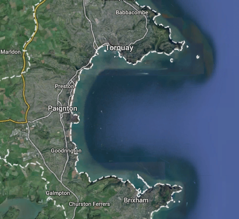
Torbay
The day is split into two, visiting two coastal outcrops around Torbay (see map) which show drastically different sedimentary processes and environments of deposition.

 In the morning we drive out to the Devonian type section north of the bay, here we find a sequence of bioclastic limestone through an ancient thriving reef system.

The students on the limestone
Here solitary and colonial corals, bryozoans, bivalves and stromataporids are all abundant in the fossil record, preserved as a life assemblage amongst very clean micritic limestone (see pictures). This shows us that, around 400 million years ago, during the the Devonian, the UK was located within the tropics and Devon, like much of the rest of the country, was covered in a warm, shallow, tropical sea, well away from any sources of terrigenous input.


Devonian fossils, 2 solitary corals, a colonial coral and a stromatoporid  (a simple sponge like animal)

Unfortunately for the reef dwellers, this idyllic spot what not to stay that way; this shallow sea was actually located near to explosive volcanic island-arc (related to the subduction of the closing ocean). Catastrophic eruptions buried the reef under up to half a metre of ash and the rarity of fossils up section from this show that this, and subsequent smaller eruptions, had a great and long lasting effect on the marine environment.

Ash layer in the Devonian limestone
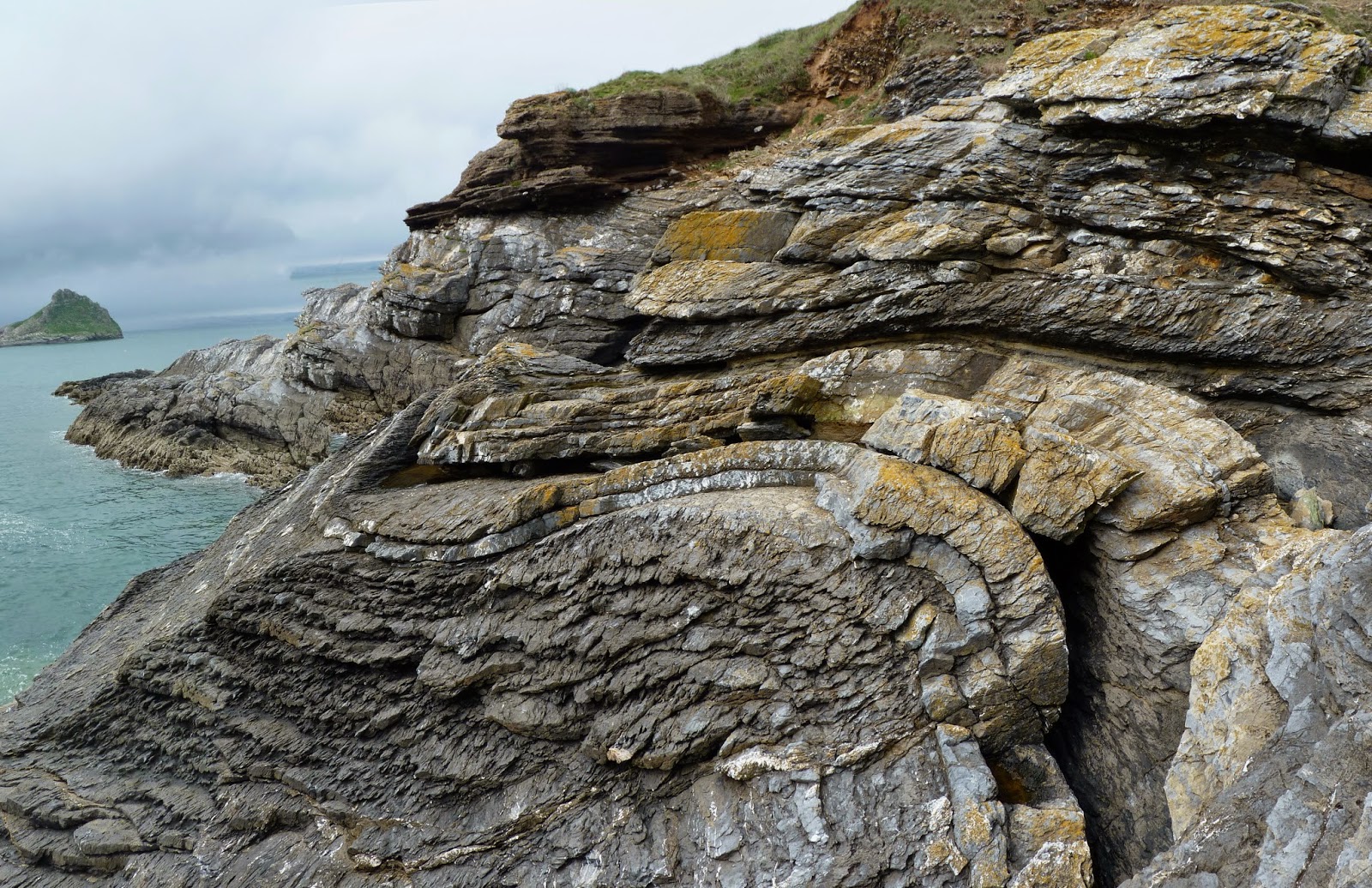
The limestone and ash beds are folded into nicely curved folds and cut by reverse faults. This is due to the distal effects of the Variscan Orogeny, as the continents of Gondwana and Laurussia came together to form the supercontinent Pangea during the late Devonian and Carboniferous periods.

Anticlinal fold in the Devonian limestone
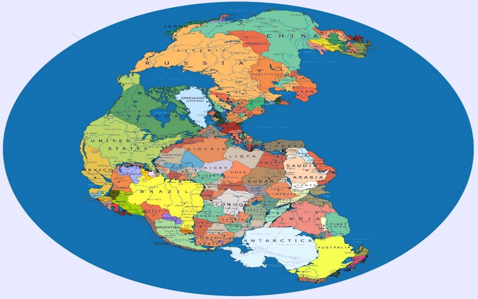
After lunch it's a few kilometers and about 200 million years to the south to Fairy Cove, Paignton. Here we find a sequence of Permian sands and breccia-conglomerates dating back to around 300-250 million years ago. These rocks are deep red in color and can be split into two sets of beds. The lower sets of beds show strong erosional bases, cross-bedding and repeated fining upwards sequences - from cobble-sized breccia-conglomerates all the way up to fine sands. It is obvious these were lain down as wadi deposits in an arid desert environment. The clasts are large, relatively angular and can be easily recognised as being mostly composed of fragments of the Devonian limestone from the morning. These rivers were rapidly eroding a young mountain belt which had been forced up by the coming together of the now vast and arid Pangea supercontinent which the UK which now part of.

Pangea in the Permian (image from)

Over time, possibly as the gradient from the mountains to the sea became shallower as the highlands eroded away, or the climate became even more arid, the power of the rivers waned.

The upper half of the sequence still shows a cyclic sequence of wadi pebble beds going up into fine sands but the clast sizes are all much smaller. At the top of many of the sequences it can be seen that flow ceased and the river bed dried out completely. At these times of increased aridity, fine muds were deposited, these dried out in the sun, shrinking and breaking up into now beautifully preserved desiccation cracks. Normally these delicate cracks do not preserve very well, being torn up by the return of the water. However, at this locality, yellow aeolian sands have been blown in by the wind and infilled the cracks, preserving them to the present day (see photo ).
Permian desert sandstones, wadi deposits with desiccation cracks infilled with (yellow) wind-blown aeolian sands
Desiccation cracks in the mud at the top of the wadi sequences

Knowing my eventual aim, after a few post-doc's, is to get into lecturing, my PhD supervisor who runs this part of the fieldcourse gave me my first taste of actual lecturing by encouraging me to sum up this site to the students in the field, which was an interesting change from the normal demonstrating.

At both sites, overlaying the sequences we find in angular unconformity with hundreds of millions of years' worth of the stratigraphic record eroded away and transgressive lag and Quaternary beach deposits, from the last glacial, just ten thousands years ago, directly overlaying the limestone and sands .

Quatary beach sediments unconformably overlaying the folded and faulted Devonian limestones 

So, being now well into the third year of my PhD, this was almost certainly my last trip to Slapton and, depending where I end up next, probably my last chance for demonstrating to undergraduates for a while. I've really enjoyed my three trips down there, they have really proved to me that Earth Science lecturing (alongside some good solid geology research) is what I really want to get into, for at least a good chunk of my academic career. I hope whoever succeeds me in being the go-to generic Earth Science demonstrator enjoys it just as much as I have, and if they come across these rambles from the last few years they find them useful.

Bonfire on the beach on the last night

Thursday 6 March 2014

Mountain Leader Training

I know it's been a few months since my last post but I've been busy writing up my thesis (3 chapters down, about 4 to do) and so very little interesting new science has been occurring. So here's a, once again not science related, post on my attempts of surviving in academia by ensuring I've got plenty of other, non-work related things going on.

Last week I completed my Mountain Leader Training with the Mountain Training Association at Plas-Y-Brenin in Snowdonia. For those who don’t know the MTA provide a series of training and assessment for qualifications for those who want to work as mountain guides, or just need to prove that they’re safe to take groups (often as a volunteer) into the hills (more details can be found here). As I've mentioned numerous times before, I am heavily involved with the University of East Anglia Fell and Mountaineering Club which, due to graduations this summer, is about to lose the majority of its ML trained members, which is why I decided now was the right time to get this training done. I also want to get this qualification as kind of a back-up plan in case I get fed up of academia and decide to just disappear off into the mountains…

Even with the worst weather that Snowdonia could through at us (Plas-Y-Brenin was still running Winter Skills courses and we saw the remains of a recent avalanche) it was a bloody good week. In small groups with qualified instructors, we covered group management while moving over steep scrambly ground around Cwm Idwal, how to waist belay up and down trickier sections of rock and then abseil yourself off, micro- and night navigation (which was particularly interesting in very high wind) and had a good expedition and wild camp into the Carneddau; even if we did have to set the tents up within a sheepfold to stop them blowing away! 

The South African abseil, one of the many useful techniques I learnt this week and am looking forward to practising on a future scramble

On top of this we all benefited greatly from the instructor’s years of experience in the uplands of Snowdonia, pointing out interesting plants and random bits of information which a guide needs to know to keep even the most disinterested child involved: like how if you turn your head 45° Tryfan looks like Homer Simpson and that sphagnum moss makes great toilet paper if you’re caught short on the hill.

See?

The accommodation, food and, somewhat brutal, bouldering wall (I had no skin left after 3 nights) at Plas-Y-Brenin were all spot on and the famous (within the university mountaineering community) cakes were delicious too.

It was a knackering week, especially as I went straight with the club to the Brecon Beacons (where some of the improved navigational skills did happen to come in handy) and was treated to some absolutely amazing conditions on the Pen-Y-Fan, Fan-Y-Big horseshoe on the Saturday.

The approach to Pen-Y-Fan on Saturday morning
I would very much recommend anyone involved in hillwalking/mountaineering activities to do this course, especially if you're part of a university club, taking less experienced friends or family out regularly or actually aspire for a job in the outdoors. Thanks to a bursary from the James Brownhill Memorial Fund I got my training half price, this fund is a charity set up to help members of university climbing clubs get training and increase safety in the mountains. It was set up in memory of James Brownhill who died in a climbing accident in Chamonix, France in 2011 and has also put a lot of my friends in the club through this training. There are many other funds and bursaries available other than the JBMF available to you even if you're not a university student, such as the Future Leaders Fund.


Now I've just got to try to get in plenty of practice and the necessary 40 ‘quality mountain days’ over the next year or so before I book my assessment; shouldn't be too difficult with a few weekends in Snowdonia, The Lakes and a week in Glen Coe already booked…Although it's trad climbing in the Peak District this weekend!